- Home
- About Us
- Services
- Subdivision
- Land Surveying
- Farm Mapping
- Computer Drafting
- Civil Engineering
- Resource Consent Application
- Aerial survey and mapping
- 3D Laser Scanning

29 Jul 2024 : MRD Web
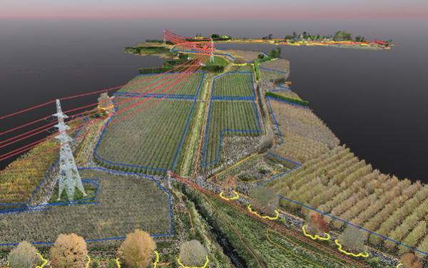
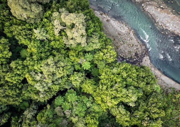
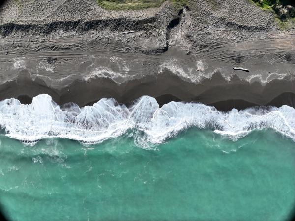
Post Cyclone Gabriel surveying is still a large part of our workload. We have completed our largest survey to date in this space, using a combination of LiDAR, photogrammetry and terrestrial surveying techniques to capture over 8km of streams and over 400Ha of surrounding flood plain land.
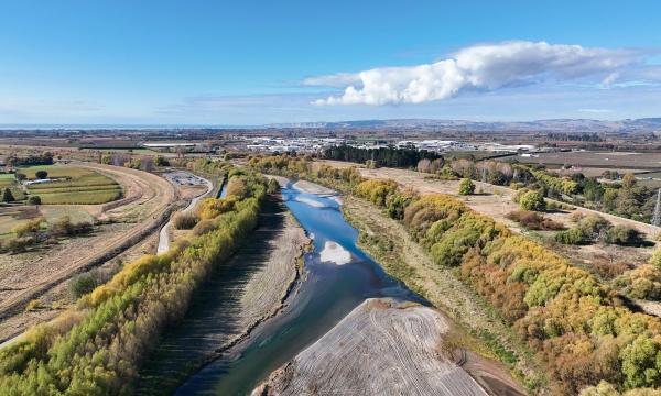
To do this we utilised all UAVs we have at our disposal including the DJI M300 with P1 and L2 LiDAR, Mavic 3 Enterprise RTK and the Trinity F90+ fixed wing survey plane.
All data was vectorised, enabling us to provide survey data in a traditional form ready for engineers to use for a range of situations, including design of stop banks and flood scenario modelling.
Part of this project involved modelling four bridges – a difficult task to do with traditional survey equipment, and an expensive task to do with a laser scanner.
Our DJI Mavic 3 Enterprise has fantastic collision avoidance systems so it is the perfect tool for close range photogrammetry. A screenshot from a video below shows just how close we can get to structures, enabling capture of fine detail.
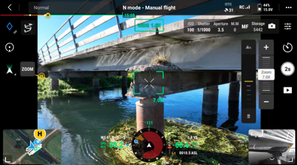
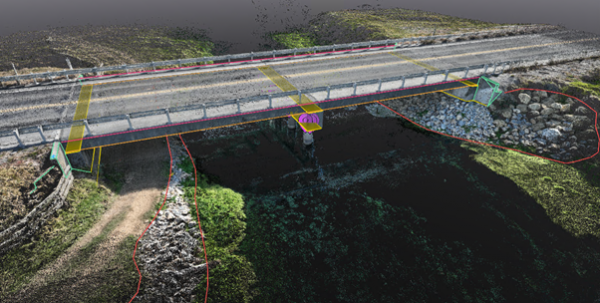
The photographic data is processed, and a point cloud is generated, from which we extract strings and points. The bridge below is on a State Highway, so was totally inaccessible on foot, without extensive (and expensive) traffic management. By using a drone instead, no traffic management was required at all, and field time was reduced dramatically, with the flight only taking just over 15 minutes.
Recently, Drone IT has become a supporter of the QEII National Trust. For nearly two decades, our parent company (The Surveying Company HB) has provided surveying support for new covenants. These covenants protect and enhance open spaces of ecological and cultural significance. Almost 70% of New Zealand is in private land ownership, so protecting biodiversity and heritage on private land is critical to reversing the decline of indigenous biodiversity and preserving New Zealand’s history.
We were involved with two new covenant areas this quarter, totalling over 100Ha. We use UAVs to map the covenants, providing us with both survey information, and condition recording of the land at the time of covenanting.
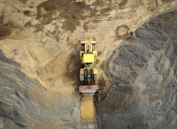
Not all of our work is local in Hawkes Bay, and we often have teams away for jobs, often in Wairoa and Gisborne. Up in these parts of NZ are many small quarries extracting necessary materials for road building. We surveyed one such quarry, providing a snapshot of the current extents, as well as volumes of stockpiles on site, and volumes left to extract.
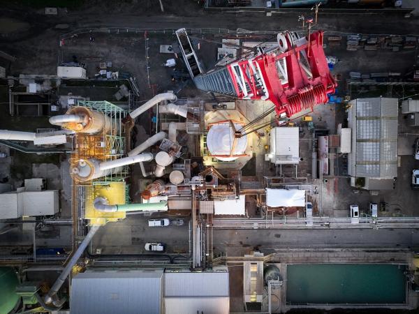
Aerial photography jobs fill in those gaps where we have a few spare hours here and there, and allows us to get out, see and capture some of Hawkes Bay’s best locations. Among this quarters jobs was a very early morning start to record a large industrial plant lift and placement by crane. We flew under the shielding provisions allowed by the CAA until daybreak, however, we were still able to capture some amazing footage of the lift.
If you haven’t done so already, check out our Facebook, Instagram and LinkedIn pages for more content.
Promises are just words unless they’re solidly backed up. We back up this promise with the guarantee that you will get your land surveying job or subdivision completed on time and to budget or you’ll get it for free.
Excellent, efficient and friendly service all through, making our subdivision process very straightforward. We can thoroughly recommend The Surveying Company
HIGHLY RECOMMENDED! Had a great experience with Seamus, made my subdivision process very smooth and simple. Very professional service and very easy to deal with. Also helped me get an exemption from the $12K contribution payment to Hastings Council!I'm a very satisfied customer!
Nick was a great help and support throughout the subdivision process. Always quick to respond to calls and collaborated well to chase up subcontractors with me as required. Would thoroughly recommend Nick and the team at The Surveying Company to any future potential clients.
Excellent
Fast, efficient and reliable. Delivered what they proposed.
From start to finish, Nick was amazing to deal with, he talked a language that I could understand, he was very professional while being very user-friendly. I would strongly recommend him to anyone wanting to subdivide. I'd like to take the opportunity to thank him for all the help he gave throughout the process, thank you Nick, you made the process very easy for us.
Regards, John
Thank you The Surveying Company, this was my first time doing a subdivision and you made it super easy. Found you easy to contact and you always made prompt responses to my queries. I would recommend you guys to others. A very seamless process from my end. Raewyn
We are very happy with the service provided by all of the people we have dealt with at The Surveying Company, thank you.
Nick Wakefield did a great job through a difficult time with COVID and everything that went with it. There were many delays with the project outside of Nick's control. A project that should have taken months took years, but Nick continued to steer the project and followed up when he could.
The level of service and expertise we received during our land subdivision using Nick and The Surveying Company was outstanding. Nick was always prompt, responsive to our many queries and fully supportive for us throughout the whole process. I would recommend Nick and The Surveying Company to anyone seeking this type of expertise and advice.
The Survey Company H.B. recently completed a subdivision of our property.
The exercise was both a pleasant and positive experience with their approach always professional - relatable, open and obliging and
communications, timely and comprehensive.
Their service commitments are excellent.
From the outset Nick and staff were very approachable and professional. The process of subdividing was clearly explained and all costs laid out before starting so there were no surprises. We really appreciated Nick's patient answering of all our questions and extra advice when we also decided to add in easements for power. The surveying staff were friendly and respectful when on site and we would have no hesitation in recommending The Surveying Company to others. Many thanks to Nick and team.
We found Nick to be thoroughly professional and easy to deal with. We were under time pressure to complete the survey. Nick explained the process thoroughly before he started work, he kept us informed throughout, and completed the work within the expected time frame and on budget.